-
Phone
13671083121
-
Address
101B, Unit 1, Building 6, Courtyard 3, Gaolizhang Road, Haidian District, Beijing
Product Categories
- LIBS elemental analysis technique
- Airborne LiDAR technology
- Plant Spectroscopy and Canopy Measurement
- Yiketai Near Earth Remote Sensing Technology
- PlantScreen Plant Phenotype Imaging Analysis Technology
- Soil moisture and SoilTron permeameter technology
- Chlorophyll fluorescence measurement technology for algae
- Soil physical and chemical properties, soil erosion observation
- Water quality analysis and water environment monitoring
- Animal Biochemical Mechanisms and Optical Imaging
- Respiratory and energy metabolism of terrestrial animals
- Chlorophyll Fluorescence Imaging and Phenotypic Analysis of Algae
- Soil respiration and carbon flux observation technology
- Hyperspectral imaging technology
- Observation of Animal Behavior and Physiological Ecology
- Photosynthesis and physiological ecological measurement monitoring
- Other instrument technologies
- EcoDrone drone remote sensing technology
- Observation of Seed and Plant Morphological Growth, Root System
- Infrared thermal imaging technology
- other
Beijing Yiketai Ecological Technology Co., Ltd
Ecodrone ® Integrated hyperspectral LiDAR unmanned aerial vehicle remote sensing system
NegotiableUpdate on 02/17
- Model
- Nature of the Manufacturer
- Producers
- Product Category
- Place of Origin
Overview
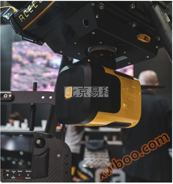
Ecodrone ® Integrated hyperspectral LiDAR unmanned aerial vehicle remote sensing system
Product Details
Yiketai Spectral Imaging and Unmanned Aerial Vehicle Remote Sensing Technology Research Center launches Ecodrone®Integrated hyperspectral LiDAR unmanned aerial vehicle remote sensing system. The system includes VNIR/NIR band hyperspectral imaging instrument and LiDAR scanner, which can simultaneously obtain target map information and 3D point cloud data in one flight. It is applied in large-scale and multi-dimensional precision agriculture research, field high-throughput phenotype analysis, forest vegetation resource investigation, ecological environment research, geological and mineral exploration, archaeological research, power line patrol, aerial surveying and other fields.

Based on Ecodrone®The integrated hyperspectral LiDAR sensor mounted on the drone platform not only captures high-resolution images of horizontal spectral reflections of leaves or canopies, but also actively emits high-frequency pulses to directly penetrate the vegetation canopy, obtaining high-precision three-dimensional structural information of vegetation and habitat structure information. It is of great significance for rapid and non-destructive in-situ monitoring of canopy and structural levels, research on forest species diversity, analysis of plant biotic and abiotic stress, and dynamic changes in the environment and ecosystem.
Performance characteristics:
l  8-rotor professional unmanned aerial vehicle remote sensing platform, equipped with AFX hyperspectral imaging, onboard PC and LiDAR, capable of flight operation for more than 20 minutes, with an effective coverage area of over 10 hectares
l Centimeter level ground resolution, with a ground resolution of 3.5cm for hyperspectral imaging at a height of 50m and 2cm for high-throughput crop phenotype analysis at a height of 30m
l 50m high single sample line flight operation can automatically collect and form a 36m wide sample strip hyperspectral imaging big data
l High density 3D point cloud with an accuracy of 2.5cm, capable of up to 3 echoes, and a point cloud density of 700pts/square meter at a flight altitude of 50m
l Professional drone remote sensing technology solution, synchronously obtaining hyperspectral and LiDAR data. The application software can directly obtain nearly a hundred plant spectral reflectance indices, high-density 3D point clouds, 3D measurement data, classification point clouds, DTM, etc
l Applied to precision agriculture research, field high-throughput phenotype analysis, forest vegetation resource investigation, ecological environment research, water resource monitoring, geological and mineral exploration, archaeological research, power line patrol, aerial surveying, etc
Main technical indicators:
Hyperspectral imaging |
Laser radar |
||
Band range/wavelength |
400-1000nm |
900-1700nm |
905nm |
Number of spectral channels |
224 |
224 |
- |
Number of spatial pixels |
1024pixel |
640pixel |
- |
Ground resolution |
3.5cm@50m AGL |
5.5cm@50m AGL |
- |
detector |
CMOS |
InGaAs |
- |
FWHM |
5.5nm |
8.0nm |
- |
Spectral sampling rate |
2.68nm |
3.5nm |
- |
Frame rate |
330FPS |
670FPS |
- |
Signal to noise ratio (peak) |
400:1 |
1200:1 |
- |
Aperture value |
F/1.7 |
- |
|
Field of view angle |
38° |
70.4° |
|
Laser Scanner |
- |
Livox AVIA |
|
accuracy |
- |
2.5cm |
|
Accuracy |
- |
3cm |
|
Scanning frequency |
- |
240k |
|
Echo frequency |
- |
Up to 3 |
|
Point cloud density @ 50m AGL 5m/s |
- |
700pts/square meter |
|
n Application Case 1: Classification Survey of Dryland Vegetation
Vegetation in semi-arid ecosystems (i.e. arid regions) plays an important role in regulating global carbon balance. However, the interweaving of different biological communities in complex environments poses significant challenges for mapping and quantifying vegetation species and structures in arid regions. To fully solve the classification problem of dryland plants, it is necessary to comprehensively consider canopy biochemistry, structure, and environmental variables. Hyperspectral remote sensing has been used to classify vegetation species in different biological communities around the world, but optical classification of large areas of arid vegetation still faces challenges from spectral mixing pixels and spectral heterogeneity. The ability of LiDAR indicators (such as canopy height) to characterize three-dimensional canopy structure provides supplementary information for optical classification. In addition, LiDAR data can export high-resolution data elevation models (DEM) to provide terrain information such as slope, aspect, and elevation for vegetation classification, which can improve the accuracy of vegetation classification coverage.
Researchers in the United States have combined vegetation optical (hyperspectral) and structural (LiDAR) information to conduct vegetation classification studies on the arid (xeric) and semi-arid (mesic) regions of the Reynolds Creek experimental watershed located in the Ohuaich Mountains of Idaho, USA. This study integrated hyperspectral spectral classification technology with LiDAR derived data, utilizing vegetation spectral information, canopy height, and terrain information to improve the classification accuracy of semi-arid ecosystems. It successfully drew abundance maps of arid areas including soil, grass, and shrubs, as well as classification maps of poplar, Douglas fir, Juniperus, and other riparian vegetation. After verification, incorporating LiDAR information into the hyperspectral classification scheme improved the overall classification accuracy from 60% to 89%.

Final vegetation cover map based on hyperspectral classification and LiDAR derived products; (Left) Messic classification and (Right) Xenic classification
n Application Case 2: Identification and Extraction of Small Area Water Bodies
Water is not only an essential natural resource, but also an important environmental foundation for biodiversity. Open pit mining is one of the human activities that have a strong impact on the environment and have a significant negative impact on freshwater biota. However, the abandoned soil and slag piles generated by mining activities have formed many water filled depressions through technological cultivation or natural succession. These small areas of water are particularly valuable for aquatic species such as Anura and dragonflies. In order to better manage water resources, protect these threatened ecosystems, and prevent biodiversity loss, it is necessary to accurately extract and repeatedly monitor open surface water bodies.
Remote sensing has been widely used to identify water bodies, but optical images are difficult to distinguish water features from other objects with low reflectivity, such as tree shadows. To address these issues, researchers from the Czech University of Life Sciences evaluated the ability of hyperspectral and LiDAR data fusion methods for precise identification of small water bodies.

(A) True color aerial photographs, (B) false color synthesis, and (C) LiDAR variable combination
The research area is located in the lignite basin in the northern part of Bohemia, Czech Republic. It mainly consists of four abandoned soil and slag piles, which contain water blocks of different shapes, heights, and sizes. In this study, an object-based classification method was used to extract open surface water bodies from abandoned soil and slag piles with very high accuracy (2% misclassification error, 0.4% misclassification error) in integrated hyperspectral and LiDAR data, with the highest accuracy compared to using hyperspectral or LiDAR data alone.

Classification differences based solely on hyperspectral data (dark blue) and comprehensive LiDAR variables (light blue)
The research results indicate that the integration of hyperspectral and LiDAR data can successfully eliminate the influence of shadows and greatly improve the recognition ability of small-scale water bodies, which is crucial for the dynamic monitoring of water bodies in habitats and ecological restoration and protection.
Yiketai Ecological Technology Company is committed to the research, development, and innovative application of ecology agriculture healthTo provide comprehensive technical solutions for precision agriculture research, forest vegetation resource investigation, ecological environment monitoring, geological and mineral exploration, environmental research, aerial surveying and other application fields using unmanned aerial vehicles and near earth remote sensing.

reference:
[1] Hamid Dashti,Andrew Poley,Nancy F. Glenn,Nayani Ilangakoon,Lucas Spaete,Dar Roberts,Josh Enterkine,Alejandro N. Flores,Susan L. Ustin,Jessica J. Mitchell. Regional Scale Dryland Vegetation Classification with an Integrated Lidar-Hyperspectral Approach[J]. Remote Sensing,2019,11(18):
[2] Science - Applied Geoscience; Findings on Applied Geoscience Discussed by Investigators at Czech University of Life Sciences Prague (Integration of Hyperspectral and Lidar Data for Mapping Small Water Bodies)[J]. Science Letter,2020:
Similar Product Recommend


